Florida Memory is administered by the Florida Department of State, Division of Library and Information Services, Bureau of Archives and Records Management. The digitized records on Florida Memory come from the collections of the State Archives of Florida and the special collections of the State Library of Florida.

State Archives of Florida
- ArchivesFlorida.com
- State Archives Online Catalog
- ArchivesFlorida.com
- ArchivesFlorida.com
State Library of Florida
Related Sites

Description of previous item
Description of next item

Florida Water Conservation League leaflet on the Proposed Ship Canal, 1941
Page
of 4
Source
State Archives of Florida, Series S406
Description
This leaflet was published around 1941 by the Florida Water Conservation League of Bradenton. The leaflet explains how salt water can intrude into Florida's underground aquifer, especially if the structure was disturbed by the proposed canal.
Date
1941 (circa)
Format
Geographic Term
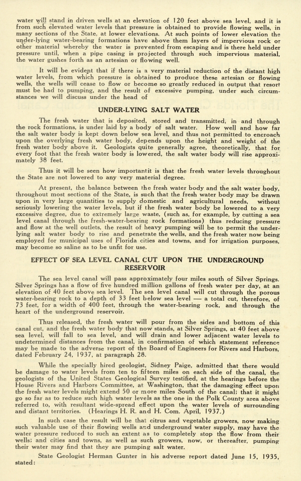
water will stand in driven wells at an elevation of 120 feet above sea level, and it is from such elevated water levels that pressure is obtained to provide flowing wells, in many sections of the State, at lower elevations. At such points of lower elevation the under-lying water-bearing formations have above them layers of impervious rock or other material whereby the water is prevented from escaping and is there held under pressure until, when a pipe casing is projected through such impervious material, the water gushes forth as an artesian or flowing well.
It will be evident that if there is a very material reduction of the distant high water levels, from which pressure is obtained to produce these artesian or flowing wells, the wells will cease to flow or become so greatly reduced in output that resort must be had to pumping, and the result of excessive pumping, under such circumstances we will discuss under the head of
UNDER-LYING SALT WATER
The fresh water that is deposited, stored and transmitted, in and through the rock formations, is underlaid by a body of salt water. How well and how far the salt water body is kept down below sea level, and thus not permitted to encroach upon the overlying fresh water body, depends upon the height and weight of the fresh water body above it. Geologists quite generally agree, theoretically, that for every foot that the fresh water body is lowered, the salt water body will rise approximately 38 feet.
Thus it will be seen how important it is that the fresh water levels throughout the State are not lowered to any very material degree.
At present, the balance between the fresh water body and the salt water body, throughout most sections of the State, is such that the fresh water body may be drawn upon in very large quantities to supply domestic and agricultural needs, without seriously lowering the water levels, but if the fresh water body be lowered to a very excessive degree, due to extremely large waste, (such as, for example, by cutting a sea level canal through the fresh-water-bearing rock formations) thus reducing pressure and flow at the well outlets, the result of heavy pumping will be to permit the under-lying slat water body to rise and penetrate the wells, and the fresh water now being employed for municipal uses of Florida cities and towns, and for irrigation purposes, may become so saline as to be unfit for use.
EFFECT OF SEA LEVEL CANAL CUT UPON THE UNDERGROUND RESERVOIR
The sea level canal will pass approximately four miles south of Silver Springs. Silver Springs has a flow of five hundred million gallons of fresh water per day, at an elevation of 40 feet above sea level. The sea level canal will cut through the porous water-bearing rock to a depth of 33 feet below sea level - a total cut, therefore, of 73 feet, for a width of 400 feet, through the water-bearing rock, and through the heart of the underground reservoir.
Thus released, the fresh water will pour from the sides and bottom of this canal cut, and the fresh water body that now stands, at Silver Springs, at 40 feet above sea level, will fall to sea level, and will drain and lower adjacent water levels to undetermined distances from the canal, in confirmation of which statement reference may be made to the adverse report of the Board of Engineers for Rivers and Harbors, dated February 24, 1937, at paragraph 28.
While the specially hired geologist, Sidney Paige, admitted that there would be damage to water levels from ten to fifteen miles on each side of the canal, the geologists of the United States Geological Survey testified, at the hearings before the House Rivers and Harbors Committee, at Washington, that the damaging effect upon the fresh water levels might extend 50 or more miles from South of the canal; that it might go so far as to reduce such high water levels as one in the Polk County area above referred to, with resultant wide-spread effect upon the water levels of surrounding and distant territories. (Hearings H. R. and H. Com. April 1937)
In such case the result will be that citrus and vegetable growers, now making such valuable use of their flowing wells and underground water supply, may have the water pressure reduced to such an extent as to completely stop the flow from their wells; and cities and towns, as well as such growers, now, or thereafter, pumping their water may find that they are pumping salt water.
State Geologist Herman Gunter in his adverse report dated June 15, 1935, stated:
Title
Florida Water Conservation League leaflet on the Proposed Ship Canal, 1941
Description
This leaflet was published around 1941 by the Florida Water Conservation League of Bradenton. The leaflet explains how salt water can intrude into Florida's underground aquifer, especially if the structure was disturbed by the proposed canal.
Source
State Archives of Florida, Series S406
Date
1941 (circa)
Format
leaflets (printed works)
Language
eng-US
Type
Text
Identifier
s406_b013_f11_02
Coverage
Florida during World War II (1939-1945)
Geographic Term
Florida
Thumbnail
/fmp/selected_documents/thumbnails/s406_b013_f11_02.jpg
Display Date
circa 1941
ImageID
s406_b013_f11_02_01
s406_b013_f11_02_02
s406_b013_f11_02_03
s406_b013_f11_02_04
topic
Land Sales and Development
Subject - Corporate
Florida Water Conservation League
Subject - Person
Macdonald, E. S.
Transcript
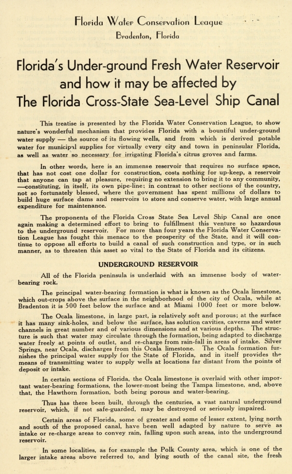
Florida Water Conservation League
Bradenton, Florida
Florida's Under-ground Fresh Water Reservoir and how it may be affected by The Florida Cross-State Sea-Level Ship Canal
This treatise is presented by the Florida Water Conservation League, to show nature's wonderful mechanism that provides Florida with a bountiful under-ground water supply - the source of its flowing wells, and from which is derived potable water for municipal supplies for virtually every city and town in peninsular Florida, as well as water so necessary for irritating Florida's citrus groves and farms.
In other words, here is an immense reservoir that requires no surface space, that has not cost one dollar for construction, costs nothing for up-keep, a reservoir that anyone can tap at pleasure, requiring no extension to bring it to any community, -constituting, in itself, its own [pipeline]; in contrast to other sections of the country, not so fortunately blessed, where the government has spent millions of dollars to build huge surface dams and reservoirs to store and conserve water, with large annual expenditure for maintenance.
The proponents of the Florida Cross State Sea Level Ship Canal are once again making a determined effort to bring to fulfillment this venture so hazardous to the underground reservoir. For more than four years the Florida Water Conservation League has fought this menace to the prosperity of the State, and it will continue to oppose all efforts to build a canal of such construction and type, or in such manner, as to threaten this asset so vital to the State of Florida and its citizens.
UNDERGROUND RESERVOIR
All of the Florida peninsula is underlaid with an immense body of water-bearing rock.
The principal water-bearing formation is what is known as the Ocala limestone, which [outcrops] above the surface in the neighborhood of the city of Ocala, while at Bradenton it is 500 feet below the surface and at Miami 1000 feet or more below.
The Ocala limestone, in large part, is relatively soft and porous; at the surface it has many sink-holes, and below the surface, has solution cavities, caverns and water channels in great number and of various dimensions and at various depths. The structure is such that water may circulate through the formation, being adapted to discharge water freely at points of outlet, and re-charge from rain-fall in areas of intake. Silver Springs, near Ocala, discharges from the Ocala limestone. The Ocala formation furnishes the principal water supply for the State of Florida, and in itself provides the means of transmitting water to supply wells at locations far distant from the points of deposit or intake.
In certain sections of Florida, the Ocala limestone is overlaid with other important water-bearing formations, the lower-most being the Tampa limestone, and, above that, the Hawthorn formation, both being porous and water-bearing.
Thus has there been built, through the centuries, a vast natural underground reservoir, which, if not [safeguarded], may be destroyed or seriously impaired.
Certain areas of Florida, some of the greater and some of lesser extent, lying north and south of the proposed canal, have been well adapted by nature to serve as intake or re-charge areas to convey rain, falling upon such areas, into the underground reservoir.
In some localities, as for example the Polk County area, which is one of the larger intake areas above referred to, and lying south of the canal site, the fresh
water will stand in driven wells at an elevation of 120 feet above sea level, and it is from such elevated water levels that pressure is obtained to provide flowing wells, in many sections of the State, at lower elevations. At such points of lower elevation the under-lying water-bearing formations have above them layers of impervious rock or other material whereby the water is prevented from escaping and is there held under pressure until, when a pipe casing is projected through such impervious material, the water gushes forth as an artesian or flowing well.
It will be evident that if there is a very material reduction of the distant high water levels, from which pressure is obtained to produce these artesian or flowing wells, the wells will cease to flow or become so greatly reduced in output that resort must be had to pumping, and the result of excessive pumping, under such circumstances we will discuss under the head of
UNDER-LYING SALT WATER
The fresh water that is deposited, stored and transmitted, in and through the rock formations, is underlaid by a body of salt water. How well and how far the salt water body is kept down below sea level, and thus not permitted to encroach upon the overlying fresh water body, depends upon the height and weight of the fresh water body above it. Geologists quite generally agree, theoretically, that for every foot that the fresh water body is lowered, the salt water body will rise approximately 38 feet.
Thus it will be seen how important it is that the fresh water levels throughout the State are not lowered to any very material degree.
At present, the balance between the fresh water body and the salt water body, throughout most sections of the State, is such that the fresh water body may be drawn upon in very large quantities to supply domestic and agricultural needs, without seriously lowering the water levels, but if the fresh water body be lowered to a very excessive degree, due to extremely large waste, (such as, for example, by cutting a sea level canal through the fresh-water-bearing rock formations) thus reducing pressure and flow at the well outlets, the result of heavy pumping will be to permit the under-lying slat water body to rise and penetrate the wells, and the fresh water now being employed for municipal uses of Florida cities and towns, and for irrigation purposes, may become so saline as to be unfit for use.
EFFECT OF SEA LEVEL CANAL CUT UPON THE UNDERGROUND RESERVOIR
The sea level canal will pass approximately four miles south of Silver Springs. Silver Springs has a flow of five hundred million gallons of fresh water per day, at an elevation of 40 feet above sea level. The sea level canal will cut through the porous water-bearing rock to a depth of 33 feet below sea level - a total cut, therefore, of 73 feet, for a width of 400 feet, through the water-bearing rock, and through the heart of the underground reservoir.
Thus released, the fresh water will pour from the sides and bottom of this canal cut, and the fresh water body that now stands, at Silver Springs, at 40 feet above sea level, will fall to sea level, and will drain and lower adjacent water levels to undetermined distances from the canal, in confirmation of which statement reference may be made to the adverse report of the Board of Engineers for Rivers and Harbors, dated February 24, 1937, at paragraph 28.
While the specially hired geologist, Sidney Paige, admitted that there would be damage to water levels from ten to fifteen miles on each side of the canal, the geologists of the United States Geological Survey testified, at the hearings before the House Rivers and Harbors Committee, at Washington, that the damaging effect upon the fresh water levels might extend 50 or more miles from South of the canal; that it might go so far as to reduce such high water levels as one in the Polk County area above referred to, with resultant wide-spread effect upon the water levels of surrounding and distant territories. (Hearings H. R. and H. Com. April 1937)
In such case the result will be that citrus and vegetable growers, now making such valuable use of their flowing wells and underground water supply, may have the water pressure reduced to such an extent as to completely stop the flow from their wells; and cities and towns, as well as such growers, now, or thereafter, pumping their water may find that they are pumping salt water.
State Geologist Herman Gunter in his adverse report dated June 15, 1935, stated:
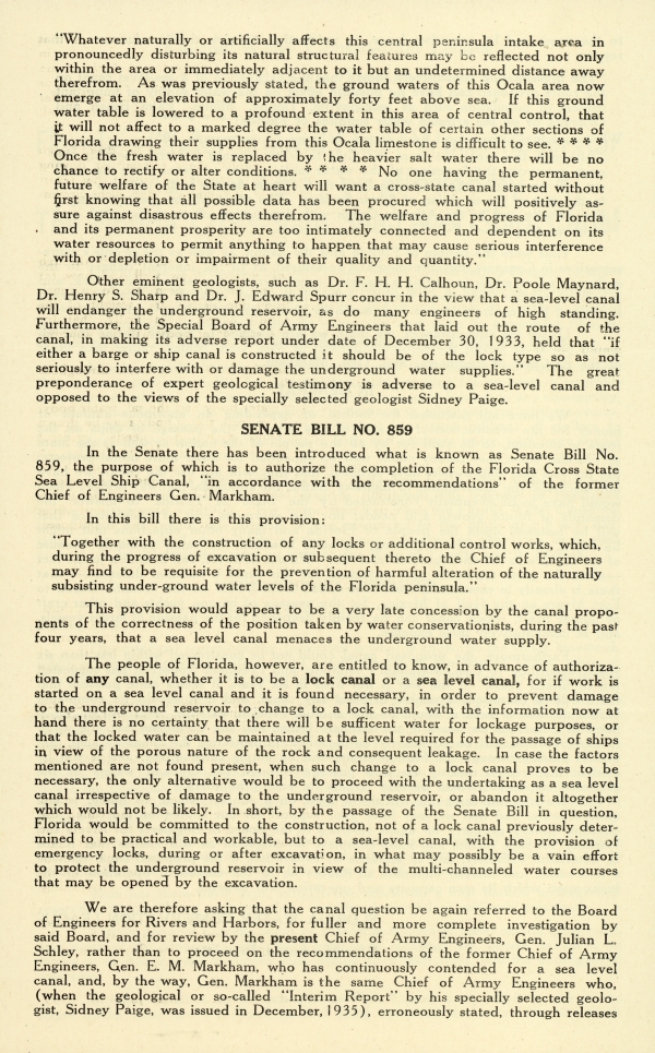
"Whatever naturally or artificially affects the central peninsula intake area in pronouncedly disturbing its natural selection features may be reflected not only within the area or immediately adjacent to it but an undetermined distance away therefrom. As was previously stated, the ground waters of this Ocala area now emerge at an elevation of approximately forty feet above the sea. If this ground water table is lowered to a profound extent in this area of central control, that it will not affect to a marked degree the water table of certain other sections of Florida drawing their supplies from this Ocala limestone is difficult to see **** Once the fresh water is replaced by the heavier salt water there will be no chance to rectify or alter conditions. **** No one having the permanent, future welfare of the State at heart will want a cross-state canal started without first knowing that all possible data has been procured which will positively assure against disastrous effects therefrom. The welfare and progress of Florida and its permanent prosperity are too intimately connected and dependent on its water resources to permit anything to happen that may cause serious interference with or depletion or impairment of their quality and quantity."
Other eminent geologists, such as Dr. F. H. H. Calhoun, Dr. Poole Maynard, Dr. Henry S. Sharp and Dr. J. Edward Spurr concur in the view that a sea-level canal will endanger the underground reservoir, as do many engineers of high standing. Furthermore, the Special Board of Army Engineers that laid out the route of the canal, in making its adverse report under date of December 30, 1933, held that "if either a barge or ship canal is constructed it should be of the lock type so as not seriously interfere with or damage the underground water supplies." The great preponderance of expert geological testimony is adverse to a sea-level canal and opposed to the views of the specially selected geologist Sidney Paige.
SENATE BILL NO. 859
In the Senate there has been introduced what is known as Senate Bill No. 859, the purpose of which is to authorize the completion of the Florida Cross State Sea Level Ship Canal, "in accordance with the recommendations" of the former Chief of Engineers Gen. Markham.
In this bill there is this provision:
"Together with the construction of any looks or additional control works, which, during the progress of excavation or subsequent thereto the Chief of Engineers may find to be requisite for the prevention of harmful alteration of the naturally subsisting under-ground water levels of the Florida peninsula."
This provision would appear to be a very late concession by the canal proponents of the correctness of the position taken by water conservationists, during the past four years, that a sea level canal menaces the underground water supply.
The people of Florida, however, are entitled to know, in advance of authorization of any canal, whether it is to be a lock canal or a sea level canal, for if work is started on a sea level canal and it is found necessary, in order to prevent damage to the underground reservoir to change to a lock canal, with the information now at hand there is no certainty that there will be sufficient water for the lockage purposes, or that the locked water can be maintained at the level required for the passage of ships in the view of the porous nature of the rock and consequent leakage. In case the factors mentioned are not found present, when such change to lock canal proves to be necessary, the only alternative would be to proceed with the undertaking as a seal level canal irrespective of damage to the underground reservoir, or abandon it altogether which would not be likely. In short, by the passage of the Senate Bill in question, Florida would be committed to the construction, not of a lock canal previously determined to be practical and workable, but to a sea-level canal, with the provision of emergency locks, during or after excavation, in what may possibly be a vain effort to protect the underground reservoir in view of the multi-channeled water courses that may be opened by the excavation.
We are therefore asking that the canal question be again referred to the Board of Engineers for Rivers and Harbors, for fuller and more complete investigation by said Board, and for review of the present Chief of Army Engineers, Gen. Julian L. Schley, rather than to proceed on the recommendations of the former Chief of Army Engineers, Gen. E. M. Markham, who has continuously contended for a sea level canal, and, by the way, Gen. Markham is the same Chief of Army Engineers who, (when the geological or so-called "Interim Report" by his specially selected geologist, Sidney Paige, who issued in December, 1935), erroneously stated, through releases
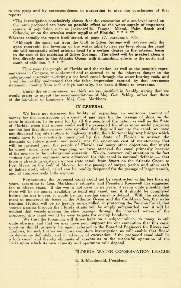
to the press and by correspondence, in purporting to give the conclusions of that report:
"The investigation conclusively shows that the excavation of a sea-level canal on the route proposed can have no possible effect on the water supply of important centers of population such as Jacksonville, Tampa, Miami, Palm Beach and Orlando, or on the artesian water supplies of Florida! ****"
Whereas actually the report itself stated, at page 27m, paragraph 105:
"Although the canal cut from the Gulf to Silver Springs will traverse only the open reservoir, the lowering of the water table to near sea level along the canal cut will necessarily affect artesian head to a certain degree in the artesian basin to the est of the meridian of Silver Springs. The effect will be greatest along a line directly east to the Atlantic Ocean with diminishing effects to the north and south of this line. ****"
Thus were the people of Florida and the nation, as well as the people's representatives in Congress, [misinformed] and re-assured as to the inherent danger to the underground reservoir in cutting a sea-level canal through the water-bearing rock, and it will be readily understood that the false impression created by that erroneous statement, coming from such a high authority, has been difficult to overcome.
Under the circumstances, we think we are justified in frankly stating that we would prefer to accept the recommendations of Maj. Gen. Schley, rather than those of the Ex-Chief of Engineers, Maj. Gen. Markham.
IN GENERAL
We have not discussed the futility of expending an enormous amount of money for the construction of a canal of any type for the passage of ships on the route in question, to be paid for by all the people of the nation as well as the State of Florida, when that money could well be expended for other more useful projects; nor the fact that ship owners have signified that they will not use the canal; we have not discussed the interruption to highway traffic, the additional highway bridges which would have to be eventually constructed by the State of Florida to answer the demands of future growth and needs; nor the enormous cost of maintenance that will be fastened upon the people of Florida and many other objections that might be urged, since, from the beginning, we have attacked the canal primarily because of the menace to the underground reservoir. We do, however, call attention to the fact - since the great argument now advanced for this canal is national defense - that there is already in existence a cross state canal, from Stuart on the Atlantic Ocean to Fort Myers on the Gulf of Mexico, for the passage of barges, yachts and other craft of lighter draft, which canal can be readily deepened for the passage of large vessels, and at comparatively little expenses.
Furthermore, the proposed canal could not be constructed within less than six years, according to Gen. Markham's estimate, and President Roosevelt has suggested ten to fifteen years. If the war is not over in six years, it seems quite possible that there will be no money available to build any canal, and if it should be completed before the war is over, it would be just another canal to defend. With the establishment of numerous air bases in the Atlantic Ocean and the Caribbean Sea, the water fronting Florida will be so heavily air-patrolled, in protecting the Panama Canal, that vessels passing through the Florida straights will be amply safeguarded, and it will be evident that vessels making the slow passage through the crooked waters of the proposed ship canal would be easy targets for enemy bombers.
We trust the foregoing will throw light on a subject which, to many, is still quite obscure, and that we may have your support for our contention that this canal question should properly be again referred to the Board of Engineers for Rivers and Harbors, for such further and more complete investigation as will enable the Board to determine definitely, and in advance of excavation, if the proposed canal shall be a lock canal, and thereby eliminate all doubts as to the successful operation of the locks upon which its own capacity and operation will depend.
FLORIDA WATER CONSERVATION LEAGUE
E. S. Macdonald, President
Chicago Manual of Style
Florida Water Conservation League leaflet on the Proposed Ship Canal, 1941. 1941 (circa). State Archives of Florida, Florida Memory. <https://www.floridamemory.com/items/show/297496>, accessed 7 January 2025.
MLA
Florida Water Conservation League leaflet on the Proposed Ship Canal, 1941. 1941 (circa). State Archives of Florida, Florida Memory. Accessed 7 Jan. 2025.<https://www.floridamemory.com/items/show/297496>
AP Style Photo Citation

 Listen: The Bluegrass & Old-Time Program

